UK snow and ice warnings as weather forecast to turn colder

Snow And Ice Forecast: Disruption Ahead
As chilly air moves in over the United Kingdom, there could be considerable snowfall that may cause travel delays.

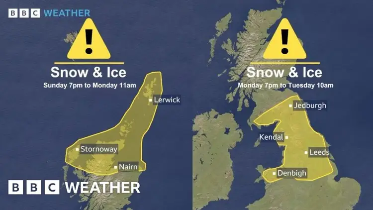
Cold health warnings and yellow alerts from the Met Office will take effect on Sunday and continue into the following week.
Daytime temperatures will be significantly cooler than the typical mid-November levels, and there will be several nights that are quite cold and frosty.
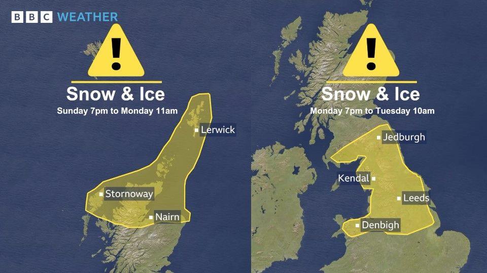
Snow may cause significant disruptions in certain areas of northern England, North Wales, and the Midlands through Tuesday morning.
UK Weather: Snow is Coming
On Sunday, snow showers are expected to arrive in Northern Scotland, with heavier snowfall likely on higher elevations.
A yellow severe weather alert from the Met Office will take effect here on Sunday evening and continue through Monday.
Higher elevations might see about 5 to 10 centimeters of snow, while lower areas in northern Scotland could receive 1 to 3 centimeters.
Temperatures are set to drop quickly throughout Scotland and northern England, leading to a significant frost in many areas on Monday morning.
Tonight is expected to be the coldest of the autumn season, with temperatures in rural areas dropping between minus 5 and minus 8 degrees Celsius.
This week, we can expect chilly and icy nights to persist, with daytime temperatures ranging from just 3 to 8 degrees Celsius.
The strong north wind will create a noticeable chill, making the temperature feel much colder.
The UK Health Security Agency (UKHSA) has announced a cold weather warning for the Midlands and Northern England, which will remain in effect for a significant part of the upcoming week.
The report indicates that weather changes may have slight effects on health and social care services. This could lead to a rise in the use of healthcare services and heightened risks for vulnerable individuals.
Heavy Snowfall For Some Areas
On Monday, we can expect heavy rainfall that may change to snow as the weather pattern moves northeast and encounters cooler temperatures.
The Met Office has released a yellow alert that will be in effect from Monday evening until Tuesday morning. This warning applies to southern Scotland, northern England, north Wales, and the northern Midlands.
In the higher areas of the South Pennines, snowfall could reach between 15 to 20 centimeters, while lower elevations might see 2 to 10 centimeters of accumulated snow. Additionally, there will be some icy patches to watch out for.
There may be travel interruptions, especially on the major trans-Pennine routes, by Tuesday morning.
Predicting snow at lower elevations can be challenging, particularly in mid-November when the ground temperatures are still warmer than they are in the heart of winter.
However, certain towns and cities will experience sleet and accumulating snow due to more intense precipitation.
On Tuesday morning, a period of sleet and snow will be passing southeast across the Midlands toward eastern England.
On Monday and Tuesday, northern Scotland will experience ongoing snow showers.
Is November Snow Really That Unusual?
Winter is still a few weeks off—officially beginning on December 1st—so is it unusual to see snow in the fall?
It's not shocking to witness snow blanketing the hills and mountain peaks of Scotland in mid-November. However, substantial snowfall in England and Wales is rather uncommon.
Typically, the weather in the UK isn't chilly enough during this season.
Even if it does snow, it might not accumulate or stay on the ground long enough to create any problems.
We would need to look back to 2010 and 1993 to encounter comparable instances when the temperature dropped enough to cause significant snowfall.
Back in late November 2010, some areas in the northeast of England and Scotland experienced snowfall of about 30 to 40 centimeters.
That cold spell resulted in the coldest December ever recorded in the UK.
Snow showers are expected to persist throughout the week, particularly in elevated areas.
How Long Will The Cold Weather Stick Around?
The chilly weather is expected to stick around for approximately a week in certain regions.
We can expect a lot of sunny and warm weather, along with some frosty mornings. However, there will also be occasional snow showers.
Intense rainfall in Scotland and northern England will persist, increasing the possibility of snowfall, particularly in higher elevations.
By the weekend, we'll experience a change to warmer south-westerly winds, bringing along some rainy and blustery conditions.
As the wetter conditions shift north, there’s a possibility of a brief snowfall before it rapidly melts away.
You can find additional details about the forecast for the remainder of November in our most recent monthly update.


