Flood warnings in place for Cambridgeshire following heavy rainfall
Cambridgeshire is currently under flood warnings and alerts due to the flooding and disturbance caused by Storm Henk.
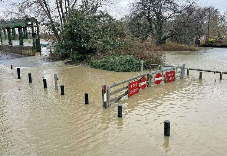
In Cambridgeshire, the river levels are increasing gradually after a night of heavy rainfall. As a result, there are currently 17 flood warnings and 32 alerts in effect.
Several alerts have been issued for flooding in the River Great Ouse region, specifically affecting the communities of Eaton Socon, Eynesbury, Eaton Ford, and St Neots.
People living in these areas have been informed about an approaching flood and have been advised that the water levels in rivers will continue to be elevated for the next several days.
The locations with the highest likelihood of danger are School Lane and Wheatsheaf Road in Eaton Socon, Wren Walk, Hardwick Road and St Marys Street in Eynesbury, St Neots Road, Mill Hill Road and Cross Hall Road in Eaton Ford, High Street, Priory Road, New Street, Hawthorn Road and Leys Road located in St Neots.
Additional alerts have been issued for potential floods in various locations along the River Great Ouse. These include Southoe, Buckden, The Offords, Brampton, Godmanchester, Huntingdon, and Hartford. At present, a flood alert is active from Brampton to Earith, suggesting that there may be a chance of flooding.
Parts of Cambridge that are most vulnerable to flooding include the downstream portion of the River Cam. This area is currently subject to a flood alert, especially in the vicinity from Stapleford to Waterbeach.
At present, there continues to be a flood warning for the upper section of the River Cam stretching from Newport located in Essex to Whittlesford situated in Cambridgeshire.
The water levels in Cottenham Lode, along with Oakington Brook, Wash Pit Brook, and Beck Brook, are on the increase, and there is a warning in place for possible flooding.
Information collected by the Environment Agency demonstrates that most of the rivers in England are currently experiencing an exceptionally elevated water level, while certain rivers have even broken their previous record for highest flow.
The UK Health Security Agency (UKHSA) has announced a cold weather warning from 9am on Saturday to 12pm on January 12, indicating a yellow alert.
The Met Office has informed that the UK is going to experience a cold snap due to the formation of high pressure which will persist throughout the upcoming week. It is advisable for drivers to exercise caution while driving in order to avoid any mishap caused by icy roads.
According to the UKHSA, there will be a strong wind blowing from the east in the southern regions during the weekend, resulting in a significant drop in temperature due to the wind chill.
The temperatures in most parts of the UK are expected to be lower than usual, particularly during the night, which may result in more frequent occurrences of frost as compared to the recent past.
The extremely damp ground in most regions will likely cause problems with ice for a lot of individuals. It's very possible that this cold period could continue all the way into next week.
According to Stefan Laeger, who is responsible for managing floods at the Environment Agency, some areas across England will still experience negative effects from flooding for the next five days even though the weather is getting drier now. This is because the levels of rivers and groundwater are still soaring high.


