UK braced for cold snap with Arctic winds set to cause ‘shock to the system’

Sign Up For Free Real-Time News Alerts!
Subscribe For Free Breaking News Updates
Subscribe To Our Free Breaking News Alerts
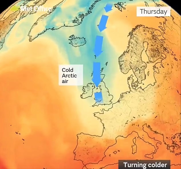
The UK is set to experience an unusually chilly few days as Arctic winds move through many areas of the country.

Friday morning could come as a bit of a surprise, as it’s predicted to be the chilliest day of the week. A blast of cold air is set to drop temperatures to around 4 to 6 degrees Celsius below the typical levels for this season.
Jonathan Vautrey from the Met Office mentioned, “A lot of us can expect temperatures in the low to mid-teens, about 13 to 14 degrees Celsius. Typically, during this time of year, we would usually see temperatures of at least 16 to 18 degrees, and in the far South East, like London, it could even be around 19 to 20 degrees.”
However, regions located further north are expected to experience a drop in temperatures to "single digits" due to strong winds, especially between Thursday night and Friday. In certain locations, temperatures might even dip below freezing.
Mr. Vautrey mentioned that we might experience some uneven frost in the countryside throughout the UK, especially in Scotland.
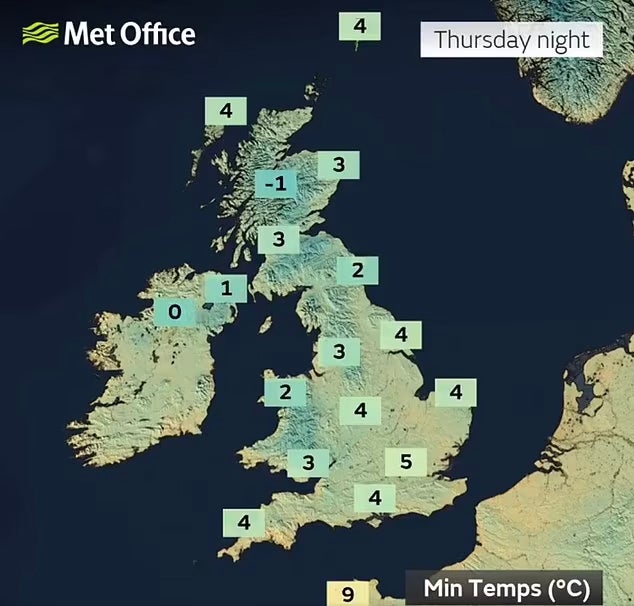
“For those stepping out on Friday morning, it might come as a surprising wake-up call.”
The tallest mountains in Scotland might experience some snow due to the chilly temperatures.
Mr. Vautrey mentioned that there is a slight possibility of snow on the tallest peaks in Scotland. However, you'll need to trek quite a distance before you actually encounter any snow.
Weekly Forecast: What To Expect Ahead
On Wednesday, expect damp, windy, and chilly conditions as a cold front sweeps through. There will be frequent and gusty showers across much of the North and West.
Rain will persist into Thursday, but many regions will also enjoy some sunshine. The weather is expected to turn a bit drier and calmer throughout the day, leading up to what will be the coldest night in the UK as we head into Friday.
Even though it will be quite cold, Friday is expected to be mostly dry throughout the UK, at least until rain moves into the North West later in the evening.
According to the Met Office, Friday marks the conclusion of the cold spell, with temperatures expected to rise again by the weekend. This change will occur as warmer air starts to push against the chilly Arctic winds.
The Met Office mentioned: "If we look ahead, warmer air from the Atlantic is anticipated to spread across the country later on Friday and, especially, into the weekend. This will halt the influx of cold air from the north and bring temperatures back to more typical levels for this time of year."
Following a rainy weekend for people in the southern regions, many are looking forward to enjoying nicer autumn weather starting this weekend.
In its extended outlook covering the period from Sunday, September 15, to Tuesday, September 24, the weather expert anticipates that temperatures will probably be a bit above average. However, due to stable weather patterns, any warm days might be balanced out by some cooler nights.
The Met Office stated: "As we approach the end of this timeframe, there are indications that the more stable weather conditions could come to an end."


